Cadillac Delta?
 There are so many lessons to be learned in the aftermath of Hurricane Katria. Scores of scientists, engineers and politicians have been convened to assess what went wrong and how to prevent a repeat of the widespread devastation should another storm hit. They all agree that the destruction of wetlands to expand oil and gas infrastructure was a major factor contributing to the severity of flooding in New Orleans. Surprisingly, they have all pretty much reached agreement on a plan to restore the wetlands around Louisiana. The plan, which would alter the course of the Mississippi River will bring a deja-vu shiver to anyone who has read Marc Reisner's "Cadillac Desert" (or seen the PBS series based on the book). Reisner details the role government-sanctioned water projects played in developing the American West. It is, in his words a "tale of rivers diverted and damned, of political corruption and intrigue, billion-dollar battles over water rights, of ecological and economic disaster." In the process, the Colorado River became the most "controlled, litigated, domesticated, regulated, and over-allocated river in the history of the world." (GW)
Time to Move the Mississippi, Experts Say
By Cornelia Dean
New York Times
Scientists have long said the only way to restore Louisiana’s vanishing wetlands is to undo the elaborate levee system that controls the Mississippi River, not with the small projects that have been tried here and there, but with a massive diversion that would send the muddy river flooding wholesale into the state’s sediment-starved marshes.
And most of them have long dismissed the idea as impractical, unaffordable and lethal to the region’s economy. Now, they are reconsidering. In fact, when a group of researchers convened last April to consider the fate of the Louisiana coast, their recommendation was unanimous: divert the river.
Far from rejecting the idea, state officials have embraced it, motivated not just by the lessons of Hurricane Katrina but also by growing fears that global climate change will bring rising seas, accelerating land loss and worse weather.
“A major diversion in the lower part of the river is something that needs to be done,” said James R. Hanchey, deputy secretary of the Louisiana Department of Natural Resources. He said the state was convening a planning meeting on the idea this fall. The diversion would be well downstream of New Orleans, in the bird-foot delta at the river’s mouth. Even so, there would be tremendous engineering challenges, particularly in finding a new way for freighters to make their way into the Mississippi’s shipping channel, said Mr. Hanchey, who took his job after retiring as director of engineering and technical services for the Mississippi Valley division of the Army Corps of Engineers. But he added, “I think it’s within the realm of possibility.”

Ellis J. Clairain Jr., interim director of the Louisiana Coastal Area science and technology program for the Army Corps, called the idea “a possible alternative.”
And Virginia R. Burkett, coordinator of global-change science for the United States Geological Survey and another participant at the April meeting, called it “the only practical solution.”
The diversion proposal was recommended by a panel of dozens of scientists and engineers from all over the world invited to Louisiana to view the state’s marshy coast and to envision its future, said Denise J. Reed, a coastal geologist at the University of New Orleans who organized the meeting.
“The thing is to stop wasting 120 million tons of sediment” the river carries into the Gulf of Mexico on an average year, Dr. Reed said. Because the bird-foot delta has grown so far into the gulf, she said, the river’s mouth is at the edge of the continental shelf. As a result, the sediment it carries ends up in deep water, where it is lost forever.
A diversion would send the river’s richly muddy water into marshes or shallow-water areas where, Dr. Reed said, “the natural processes of waves, coastal currents and even storms can rework that sediment and bring it up and bring it into the coast.”
“It’s a lot,” she said, enough to cover 60 square miles half an inch deep every year, an amount that would slow or even reverse land loss in the state’s marshes, which have shrunk by about a quarter, more than 1,500 square miles, since the 1930’s. Such a program would not turn things around immediately, “but every year new land would be built,” said Joseph T. Kelley, a professor of marine geology at the University of Maine, who took part in the April meeting.
As the bird-foot delta broke up, Dr. Reed said, it would provide needed sediment to the frail strings of barrier islands that line some of the Louisiana coast.
Another potential benefit, Mr. Hanchey said, would come from the substantial nutrient runoff from inland agriculture in chemicals that contribute to the so-called dead zone of oxygen-poor water near the river’s mouth. Applied to the marsh, the nutrients might encourage desirable plants, he said.
Designing such a diversion would be complex and time-consuming, and the experts who met in April did not even attempt it. Even this fall’s meeting is not to plan the project, but to plan how the project should be planned, Mr. Hanchey said. Though Louisiana is rich in experts on river, wetland and coastal science, he said, state officials hoped to recruit scientists and engineers from all over the world to tell them “what we would have to know before we could initiate work on something like this, and what we would have to do to gain that knowledge.”
In a way, the bird-foot delta is an artifact of engineering. Without the levees and other structures that keep the river in place, it probably would have taken another path.
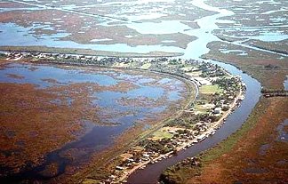
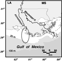
Like many major rivers, the Mississippi has tributaries, which feed water into it, and distributaries, which carry water away from it as it nears its mouth. Its tributaries include the Missouri and Ohio Rivers; one way or another, every stream, storm drain and parking lot from the Rockies to the Appalachians drains into the Mississippi. But about 250 miles from the gulf, near Lettsworth, La., the river stops taking water in and starts feeding it out, into the gulf through the main stem of bird-foot delta but also in distributaries like the Atchafalaya River, which flows into Atchafalaya Bay to the west.
Until people interfered with its flow, the Mississippi’s path to the gulf silted up naturally over time; water flow slowed and the river bed lost its capacity to carry a big flood. When next the big flood came, the river would suddenly turn one of its distributaries into its new main stem.
This kind of switching has occurred roughly every 1,500 years, geologists say, and since about 1950 the river has been ready for a change — to the Atchafalaya. The Corps of Engineers prevents that from happening with an enormous installation of locks, dams and power stations near Lettsworth, north of Baton Rouge and about 100 miles northwest of New Orleans.
Simply letting the Mississippi shift to the Atchafalaya would do a lot for the sediment-starved marshes west of the Mississippi. But it would leave cities like Baton Rouge and New Orleans — and the petrochemical infrastructure between them — without fresh water or a navigable waterway.
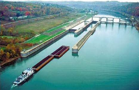
The diversion the scientists propose would be much farther downstream, but where exactly is not at all certain. One possible location is near Davant, about 45 miles southeast of New Orleans. Another is near Empire, further down the river, where the levees could be opened. In either case the river flow into wet and marshy areas to the west. Another way would have to be found — or constructed — for ships to reach the shipping lane, possibly something engineers call a slack-water channel.
As Dr. Clairain explained, “You divert the river, and then you create an avenue in which you are not allowing the river or the sediment to pass,” a channel or lock in which water does not move. “The ship comes up to whatever control you have” — a gate or the like — “and the ship passes through and then the control is reinstituted.”
He said he was not aware of similar installations on this scale elsewhere but said, “We have a lot of great people in the state and around the nation who are contemplating these kinds of solutions.”
Almost certainly, he and others say, such an approach would require vast new construction. Dr. Clairain said it was unlikely planners would consider using the Mississippi River Gulf Outlet as a shipping channel. Known as Mr. Go, this outlet, just southeast of New Orleans, was blamed as a path for some of the floodwaters that inundated the city in Katrina. Chief among its drawbacks as a shipping channel would be the difficulty of keeping it dredged for big ships.
Other issues include the fate of those who live south of the proposed diversion, compensation for land lost to the project and ownership of any land created by it.
Mr. Hanchey said relatively few people would have to be relocated.
“The closest community is Venice, at the end of the levee system, about 10 miles north of Head of Passes,” where the river splays into the gulf, he said, but its population even pre-Katrina was tiny. South of that is Pilottown, but that, he said, is little more than a place for river pilots to stay while they wait for ships.
“There might also be some oyster-lease issues, but those would be minor,” he said.
Another question has to do with land rights. Oliver Houck, a professor of environmental law at Tulane University, said fishing access and oil and gas rights are the crucial land issues in Louisiana. “Under traditional land regimes,” Professor Houck said newly created riverside or marsh land belongs to the abutting landowner. “The wild card here is, what if you gain it through a huge federal-state project?”
But Mr. Hanchey and Mr. Houck say those issues can also be dealt with relatively easily. Navigation is a bigger problem.
People involved in the proposal recognize that the lower Mississippi is “a working landscape” that must continue to function, said James T. B. Tripp, a lawyer for Environmental Defense and a member of the Louisiana Governor’s Commission for Coastal Restoration.
“One of the major obstacles to doing any of this pre-Katrina was the navigation industry,” he said. “As a result of Katrina, everyone’s thinking has become more flexible. Katrina brought all that home: how vulnerable this economic infrastructure has become. So there is a greater readiness today to think more boldly about how we can manage the river in a way that will help restore and build wetlands.”
Of course the proposed project will be expensive. But Mr. Tripp said there were already “three or four” available financing sources, including coastal oil and gas revenues and other money already approved for coastal restoration.
“Is it practical? Yes,” he said. “Will it be expensive? Yes. But when you look at the alternatives it’s very cost effective,” particularly in an era of rising sea levels.
Obviously, no one wants to make irrevocable changes in the flow of the Mississippi River only to find out they cause more problems than they solve. Could that happen? “I think it’s possible,” Mr. Hanchey said.
But he added: “Our ability to understand and model river responses to actions like this has improved. The technology of hydrodynamic modeling has improved, and of course we have tremendously increased computational power we did not have before. We can run models today in a matter of hours that took weeks even 20 years ago. All of that has improved.
“Still, whether we can model the river precisely I don’t know. It’s going to require a lot of data. It’s going to require a lot of brains. There are probably a limited number of people in the world who have worked on something as large as the Mississippi River.”
Dr. Clairain said the idea of constructing a project and then watching unanticipated consequences lead to disaster “is the kind of thing the Corps of Engineers as a whole worries about.” He continued: “We are talking about doing projects that can have huge impacts to large portions of the nation, the economy, the people. If the project does not deliver all the ecosystem benefits you are hoping it will, you can make tweaks and the ecosystem will survive. That’s not true of flood control and economics.”
But there is a growing recognition that the cost of not acting will be high as well.
Along the Louisiana coast, in the delta plain along the river and the oaky woods along Chenier Plain to the west, much of the land is only a few feet above sea level. If seas rise as expected by two or three feet, or more, in the next century, and if the muddy sediments that form this landscape continue to compact and subside, land loss will only accelerate.
Given the proposal’s many unknowns, it is hard to say how soon water might begin to flow from the river into the marshes. If there is a decision to go ahead, designing the project might take three or four years, Mr. Hanchey said. “And then of course to build something like this — depending on what this thing ended up looking like, it would take another 5 to 10 years,” he said.
Meanwhile, Dr. Reed said, participants in the April meeting are going to produce “a scholarly report” outlining their views in more detail.
"We want to get the citations and the context and the substance behind the arguments,” she said. Dr. Reed said she was “invigorated” by the support the idea had received. “My job is to try to carry it through,” she said, “and make sure people don’t forget about it.”
Click here to go to the original New York Times article.
posted by Karamuse at 6:29 AM
![]()

0 Comments:
Post a Comment
<< Home